Across the Gulf of Mexico, oil continues to wash ashore, exposing gaps in response efforts and raising concerns about long-term environmental damage.
By Diego Gastélum
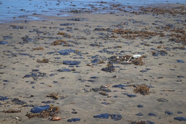
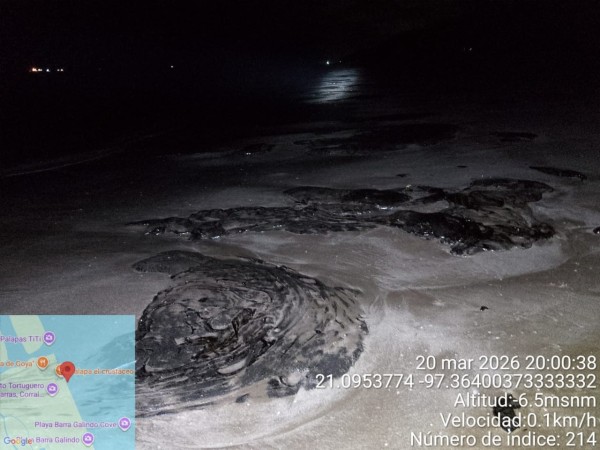
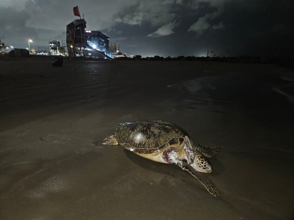
Along the northern coast of Veracruz, oil is washing ashore in pieces — tar balls in the sand, black residue in mangroves, dead turtles and dolphins.
It is also arriving without answers.
Since mid-March, an oil spill with no confirmed source has spread across roughly 630 kilometers of coastline, covering nearly the entire Southwest Gulf of Mexico Reef Corridor — a critical marine ecosystem that stretches from Veracruz to Tabasco.
The scale points to a major environmental disaster. The response does not.
Cleanup Claims vs. What’s on the Ground
On March 19, Mexico’s state oil company, Pemex, said cleanup efforts were about 85% complete. On the ground, that figure is hard to verify.
A coalition of scientists, community groups and environmental organizations — the Red Corredor Arrecifal del Golfo de México — reports that at least 26 contaminated sites have received no official cleanup. In several others, residents are doing the work themselves, often without protective gear.
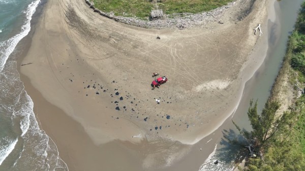
So far, 51 locations show evidence of oil contamination: 42 in Veracruz and nine in Tabasco. In some places, oil has returned days after cleanup crews left, carried back by currents and seasonal winds.
Response efforts have focused on tourist beaches. Remote areas and ecologically sensitive zones — including mangroves — have largely been left behind.
The Damage We Can’t Yet Measure
The bigger damage may be underwater. The reef corridor includes at least 125 coral and rocky reef systems. No comprehensive assessment of their condition has been made public.
These reefs support fisheries that sustain about 16,000 families. Without baseline data, it will be difficult to measure the long-term impact — or recovery.
Environmental groups are also warning against the use of chemical dispersants, which can push oil deeper into the water column and increase toxicity for marine life, including corals and shellfish.
Wildlife Is Already Paying the Price
The toll is beginning to surface. At least seven sea turtles, two dolphins, two manatees and one pelican have been found affected by oil. Most were dead.
The spill comes just as nesting season begins for five endangered sea turtle species in the region. In the Laguna del Ostión, oil has already reached mangrove ecosystems that serve as nurseries for marine species and habitat for protected wildlife.
Coastal Communities Left Exposed
For coastal communities, the crisis is immediate.
Fishing has stopped in several areas for weeks. Tourism operators are bracing for losses during peak season. And those helping clean the النفط are being exposed to toxic compounds.
Crude oil contains polycyclic aromatic hydrocarbons — chemicals linked to cancer, immune damage and other long-term health risks. Exposure can happen through skin contact, inhalation or contaminated food.
Despite this, affected communities have not received compensation. Existing government aid, local groups say, falls far short of covering economic losses.
No Source, No Accountability
Authorities have not identified where the oil is coming from.
Early reports suggested a leak from a vessel, but that has not been confirmed. Another possibility is a spill detected in February in the Bay of Campeche. Ocean current models show oil from that region could reach Veracruz within weeks.
Without a confirmed source, no one has been held accountable. There is also no guarantee the spill has stopped.
A Pattern, Not an Exception
The Gulf of Mexico has a long history of oil spills. From the Ixtoc I blowout in 1978 to the Deepwater Horizon disaster in 2010, large-scale accidents have repeatedly exposed the risks of offshore drilling.
A historical review cited in the report documents at least 30 oil well incidents in Mexico between 1886 and 2024. This spill fits that pattern.
The map of disaster
A map compiled by the Red Corredor Arrecifal del Golfo de México documents the full geographic spread of the spill across more than 630 kilometers of coastline, identifying at least 51 contaminated sites — 42 in Veracruz and nine in Tabasco — along with their cleanup status. The data shows a fragmented response: some areas have received no official attention, others have been partially cleaned by authorities or Pemex, and in several cases, local communities have carried out cleanup efforts on their own.
What Comes Next
The Red Corredor Arrecifal del Golfo de México is calling for an official environmental emergency declaration, a halt to oil operations in affected areas, and full transparency about the source of the spill.
It is also calling for something more difficult: long-term restoration of ecosystems that may already be permanently damaged. For now, the oil keeps coming ashore.
And along Mexico’s Gulf coast, the question is no longer whether there is a disaster — but how much of it remains unseen.